


Waterfalls, wilderness areas, wildflowers and epic views… No, we’re not talking about a national park somewhere out west, but our very own Foothills Trail! Backpacker magazine rated it as “one of the best long trails (fifty-plus miles) in the country,” and it traverses the Jocassee Gorges, which National Geographic named one of “50 of the World’s Last Great Places—Destinations of a Lifetime”… this isn’t just any walk in the park! Well-suited for a through-hike for families looking for a challenge, yet accessible even for the shortest day-trip ramble, the Foothills Trail is rapidly gaining notoriety as one of the premier trails in the southeast.

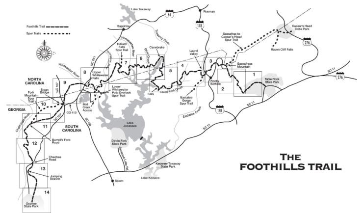
Totaling 77 miles, the trail stretches from Oconee to Table Rock State Park with additional spur trails to numerous waterfalls and Caesars Head State Park. Major trailheads are located at the state parks, as well as US 178, SC 130, and SC 107. You’ll find all this and more on the Foothills trail’s website, and this interactive map has access points, campsites, water sources, and other info.
It can be daunting to choose the right hike for your family. We’ve put together a guide to help identify shorter hikes on the Foothills Trail that will take you to points of interest, as well as give you the info you’ll need to plan your trip: parking, hike difficulty, cost, etc. The trail has been broken down into sections, the numbers corresponding to the system the Foothills Trail Conservancy uses on their website: “A” denoting access points and “S” spur trails.
A Short History of the Foothills Trail
The push to protect the Appalachian Foothills began in the 1960s, with Clemson University and the US Forest Service (USFS) leading the way. The first component connecting Oconee to Table Rock was built in Sumter National Forest by the USFS, and by the early 1970s, the Foothills Trail effort was gaining momentum. Duke Power offered to build and maintain the central section of the Foothills Trail during the process of planning the Bad Creek Hydroelectric project, and in 1974 the Foothills Trail Conference was established.
The 77-mile trail linking Oconee and Table Rock State Parks was finished in 1981, and for the last 40 years the Conservancy has promoted and supported the trail through trail maintenance and developing the Foothills Trail Guidebook and map. To become a member, please visit the FTC’s website! Join Now – Foothills Trail Conservancy
The Foothills Trail
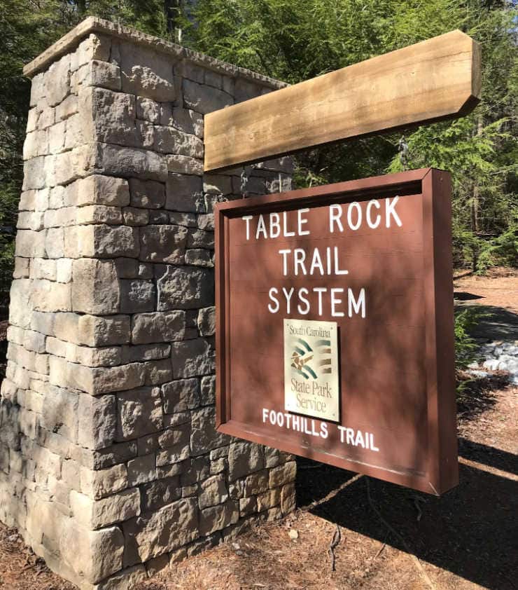
Table Rock State Park (A1)
Chances are, you’ve been on the Foothills Trail already, as a portion of this section shares trail with the beloved Carrick Creek Trail in Table Rock. The one mile of trail that follows Carrick Creek up from the Nature Center has a waterfall, countless cascades, and has a gentle grade with well-maintained trail, perfect for younger children.
From there you can keep hiking, although the trail gets much steeper. A short spur goes up to the summit of Pinnacle Mountain, but all the views are found along the Foothills Trail: Bald Knob (3.6 miles from Table Rock) and Drawbar Cliffs (4.6 miles from Table Rock). Both make great destinations, though be warned they are difficult hikes; less experienced hikers will want to stick to Carrick Creek!
The easy way out(side): Carrick Creek loop trail
Know before you go: State Park pass or park admission required, hikers must register at kiosk at Nature Center.
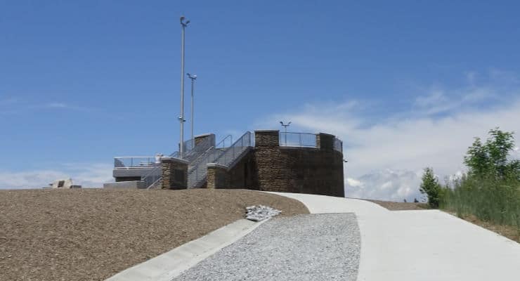
Sassafras Mountain (A2)
Another spot on the Foothills Trail you may have already checked out is Sassafras Mountain. Remember, as it’s the highest point in the state, any direction you hike from the summit will be descending… which means you’ll have to go back up to get to your car!
The easy way out(side): The observation tower and the rock outcrops located adjacent to the medium-sized parking area guarantee that you will not have to go far to soak in those views! Remember to bring a picnic to enjoy at one of the picnic tables.
Know before you go: Parking is free, but the road up can be closed in the winter for inclement weather; to check on the status, call the Pickens County Sheriff’s Office at 864.898.5500.
Chimneytop Gap (A3)
Just two miles from the summit, the section of trail from Chimneytop to the top of Sassafras makes for a nice day hike. Start at the Chimneytop parking area to get the hard part out of the way first; the views at the peak will be so much more spectacular as for having earned them with the climb up!
The easy way out(side): Park at Chimneytop and hike the Beech Bottom Falls trail
Know before you go: Up until Sassafras the Foothills Trail has just been passing back and forth into the Jim Timmerman Natural Resources Area at Jocassee Gorges, but after Chimneytop it heads right into the heart of the wilderness area. Be prepared for fewer road access points and limited cell service!
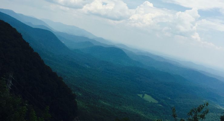
Caesar’s Head Trail: Sassafras (S1) to Caesars Head (S2) spur
The 14.2 miles from Sassafras Mountain to Caesars Head are strenuous, but the trail borders Greenville watershed property, some of the most pristine forest in South Carolina. A highlight of this section is Raven Cliff Falls, the tallest waterfall in the state. To reach a viewing platform across the valley from the falls, hike in from the Caesars Head SP end (use the Raven Cliff Falls parking area) – the 4-mile in-and-out hike is moderate in difficulty.
The easy way out(side): Park at the Caesars Head Visitor Center and walk out to the overlook to get a birds-eye view of the terrain.
Know before you go: State Park pass or park admission is required, hikers must register at kiosk. The parking lot fills up fast, plan to get an early start and have a backup plan if the overflow lot is full.
Laurel Valley (A4)
The medium-sized parking area on Horespasture Road serves as a gateway to the Jim Timmerman Natural Resources Area at Jocassee Gorges and marks the last vehicle access point to the Foothills Trail for many miles. A popular day-hike destination from this trailhead is Virginia Hawkins Falls, an 8.5 round trip, although by driving a bit further on Horespasture Road you can reach a second trailhead that cuts down the mileage to 2.6 miles in-and-out.
The easy way out(side): Take a slow, scenic drive on Horsepasture Road, with a stop at Jumping Off Rock to take in one of the most epic views of the Jocassee Gorges.
Know before you go: Horsepasture Road is a primitive road maintained by the SC DNR. It’s open year-round, but allow for extra travel time – the 9 miles to Jumping Off Rock can take around an hour.
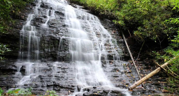
Eastatoe Gorge: Laurel Valley (S3) to the Narrows (S4)
A moderate hike of 5.4 miles round trip (with a steep, if short section that might tend towards strenuous), a Foothills Trail spur takes hikers into the Eastatoe Creek Heritage Preserve. This section is characterized by amazing spring wildflowers and a view of Eastatoe Creek as it funnels through a narrow rock channel called “the Narrows.”
Know before you go: Park at the Laurel Valley parking area, not at the gate a little further up the road where the trail enters the forest – the road there serves as emergency access, and blocking the gate can get you heavy fines and possibly towed.
Bad Creek Access (A7)
The Bad Creek Hydroelectric Site is a 360 acre “pump-back” storage facility that pumps water from Lake Jocassee and stores it until needed for peak energy demands. It has a scenic viewpoint over Lake Jocassee as well as a public parking area providing access to the Foothills Trail, the Jocassee Gorges Wildlife Management Area, and Lower Whitewater Falls.
The easy way out(side): It is 0.7 miles one-way from the parking area to the Foothills Trail and Whitewater River, a nice destination for those looking for a short hike with some time by the water. The viewing platform for Lower Whitewater Falls is a little more of a challenge, 4 miles in-and-out.
Know before you go: There are three boat access points to the Foothills Trail in the 33 miles from Laurel Valley to Bad Creek Access (Laurel Fork A5, Canebrake A6 and Horsepasture River) and a 5-mile connector trail (Cane Brake Trail from Frozen Creek), though no vehicle access save for a few intersections with 4WD forest roads. This is a popular section for camping, especially with families and novice hikers looking to get a feel for backpacking.
The Foothills Trail Hiking group on Facebook can be very helpful for planning purposes, with advice from experienced hikers/campers as well as up-to-date trail conditions. It is very important to be well-prepared if entering this section, as there is little-to-no cell service, and you are crossing through the heart of the Jim Timmerman Natural Resources Area at Jocassee Gorges in addition to Laurel Fork Heritage Preserve, NC Gorges State Park and the NC Gamelands.
Upper Whitewater Falls (A8)
The NC Hwy 281 Upper Whitewater Overlook parking area proves access to spectacular views of Upper Whitewater Falls, the highest waterfall east of the Rockies!
The easy way out(side): A paved, accessible, ¼ mile trail leads to the upper observation area, then 154 steps further you’ll have reached the lower observation area. You can continue on to descend to the river – just remember, you’ll have to climb back up!
Know before you go: A parking fee of $3 per vehicle goes toward continued improvements of the park. Please don’t venture off-trail, as deaths and serious injuries have occurred here!

Sloan Bridge (A9)
The 5.5-mile hike from Whitewater to Sloan Bridge is along a ridge, and has superb views of Jocassee in the winter, but the majority of visitors are drawn to Sloan Bridge for a picnic at one of the tables, to cool down in the East Fork of the Chattooga River, or for a short hike to one of the several waterfalls to the south.
The easy way out(side): After a picnic at Sloan Bridge, drive over to the nearby Wigington Overlook for a picture-perfect view of Lake Jocassee.
Know before you go: There are no trash receptacles at Sloan Bridge Picnic Area; remember, if you pack it in, please pack it out!
Fish Hatchery Road (A10)
It’s just 3.3 miles to Sloan Bridge from Fish Hatchery Road, and with multiple trails in the area, many hikers plan a loop to make a day out of their visit to this corner of the state.
The easy way out(side): Just a little bit further up the road is the Walhalla State Fish Hatchery: take a self-guided tour, go fishing, have a picnic, and enjoy the natural beauty of the Ellicott Rock Wilderness Area!
Know before you go: A visit to the Walhalla State Fish Hatchery is free, but if you want to feed the fish, bring quarters for the fish food dispensers.
Burrell’s Ford (A11)
There is so much to do in this remote corner of the state! In addition to numerous major waterfalls, Burrell’s Ford offers camping, fishing, and picnicking along the Chattooga Wild & Scenic River. For more on Burrell’s Ford, see our article Burrells Ford Campground: Camp Near Scenic Waterfalls in Upstate, SC.
The easy way out(side): Enjoy a hike to King Creek Falls or Spoonauger Falls.
Know before you go: Burrell’s Ford is free, but can be popular on weekends. Get there early for parking and first choice of a campsite!
The Highway 107 access points
Headed south on Highway 107 from Sloan Bridge you’ll pass several access points to the Foothills Trail. However, being small dirt lots that only have room for a handful of cars, we’ve grouped them together for this guide.
- Nicholson Ford Access: This access point to the Foothills Trail is also the trailhead for hikes to Licklog and Pigpen Falls (Explore Licklog and Pigpen Falls via Foothills Trail | AllTrails). The gravel road can sometimes get a little washed out, if you would rather stay on pavement park at Cheohee Road.
- Cheohee Road (A12): Just off Highway 107, Cheohee Road is also known as Winding Stairs Rd. A gravel forest road leads to several popular waterfalls and a Forest Service campground.
- Jumping Branch Trailhead (A13): The last access point before entering Oconee State Park!
Oconee State Park (A14)
The southern terminus to the Foothills Trail, Oconee also serves as a connector to Oconee Station via the Palmetto Trail. You can find the KAG guide to this State Park here; Oconee State Park: Play Mini-Golf at this SC State Park.
The easy choice: Enjoy Oconee State Park! From multiple hiking trails leading to historic sites, views, and waterfalls, to putt-putt golf, boat rentals, and a beach – Oconee has got it all!!
Know before you go: State Park pass or park admission is required, hikers must register at kiosk at Nature Center
Hike the Entire Foothills Trail
Hikers who complete all 77 miles of The Foothills Trail—from Oconee State Park to Table Rock State Park – are eligible for the Peregrine Award, which was started in 2011 in honor of longtime FTC member Heyward Douglass. The word “peregrine” comes from the Spanish word “peregrino,” which means pilgrim. It is also the name of one of Heyward’s favorite birds; he was instrumental in the re-introduction of the Peregrine Falcon to the mountains of Upstate South Carolina. For more information, please visit the Foothills Trail website.
Hopefully, this guide helps you identify which sections of the Foothills Trail are closest to your home, and will assist in figuring out how you can best get your family out on the trail this summer! Please remember to hike within your comfort and skill level, and always plan ahead – research the trail, local regulations, weather, hazards, and what to do in an emergency. Happy hiking!
This post was originally published on the blog Femme au Foyer.